 |
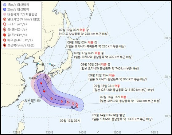
According to the Korea Meteorological Agency on 14th, Typhoon No. 14 developed to 996 hectopascals, a maximum wind speed of 18 meters per second, and a strong wind radius of 230 kilometers at 3:00 am on the same day, over the sea about 1280 kilometers east-southeast of Okinawa. It is heading east at a speed of 13 kilometers per hour.
According to the Japan Meteorological Agency, Typhoon No. 14 changed its course to the west from the afternoon of 14th, and at around 3:00 am on 17th, the central pressure was 975 hectopascals, the maximum wind speed was 32 meters per second, and the strength of the typhoon was at the "medium" level. It is estimated that it will advance over the sea about 370 kilometers east-southeast of Okinawa, the south part of Japan.
After that, it is expected to develop to a "strong" level before dawn on 18th, pass between Okinawa and Kyushu, and reach the sea about 280 kilometers south-southeast of Seogwipo, Jeju around 3:00 a.m. on 19th.
No forecast has been released for 19th and beyond, but at this point it is possible that it will move northward across the Korean Peninsula or make landfall in Kyushu.
2022/09/18 09:33 KST