They warned that a typhoon stronger than this year could hit. According to the Korea Meteorological Administration on the 19th, as of 1:30 pm on the same day, Typhoon No. 9 was moving north from the sea about 240 km southwest of Okinawa. Typhoon
Typhoon No. 9 is expected to be the first typhoon to affect the Korean Peninsula this year. The central pressure was 1,000 hectopascals (hPa), and the maximum wind speed near the center was 19 meters per second.
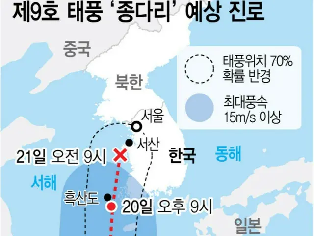
Typhoon No. 9 is expected to affect the Korean Peninsula from the early hours of the 20th. At around 3 a.m. on the 20th, it reached a point about 230 km south of Heuksan Island, South Jeolla Province.
The Korea Meteorological Administration believes that the typhoon is likely to pass over the nearby seas, approach the west coast of South Korea, move northward, and then make landfall in North Korea via the Hwanghae (Yellow Sea) Province.
There are variable factors such as the inflow of dry air currents into the area, and it is possible that the typhoon will land inland. Cho Jeong-ho, former director of the National Institute of Meteorological Sciences, said that the recent rise in temperature has caused the typhoon to contain more water vapor than usual, and that the typhoon will be stronger than usual.
He added, "When the North Pacific high pressure system is over the Korean Peninsula, the chances of a typhoon hitting South Korea are low, but if this high pressure system moves south,
"The typhoon will pass along the edge of the North Pacific high pressure system. Korea will be included in the typhoon's path," he explained. In fact, Typhoon No. 9 is also moving north along the edge of the North Pacific high pressure system.
However, in the case of this typhoon, it is highly likely that it will weaken and turn back into a tropical depression as it moves northward through South Korea. As Typhoon No. 9 moves northward, the scorching heat and tropical nights that have continued for days are likely to become even more intense.
This is because the hot and humid air from the North Pacific high pressure system continues to affect the Korean Peninsula, and the hot water vapor from the typhoon itself is also flowing in. In fact, it is expected to reach 20 to 20 km/h by Seoul standard.
The morning low on the 1st was forecast to be 28 degrees, about 4 degrees higher than average. Cho, the former director, recently commented on the heatwaves, "When we analyzed data from the past 100 years, we found that winters were shortened by about one month and summers were shortened by about one month.
"The rain this week will ease the heat a little, but tropical nights and extreme heat will continue until early next week," he said.
Cho said the high pressure system on the south side of the river will expand, causing a double high pressure system that will continue to cause extreme heat. As a result of this typhoon, Jeju and the southern region are expected to receive up to 100mm of rain.
The expected rainfall on the 20th and 21st, when the typhoon will enter its full-blown storm zone, is 30 to 80 mm in Jeju (over 100 mm in some areas), 30 to 80 mm in Busan, Ulsan, and Gyeongnam.
) 30-80mm (over 100mm in some areas) △Gwangju, Cheongnam, and Cheonbuk 20-60mm (over 80mm on the south coast of southeastern Jeolla) △Daejo
Daejeon, Se Jeong, Chungnam, Chungbuk: 10-50mm △Seoul, Incheon, Gyeonggi, Gangwon: 10-40m
m. For the south and west coasts, swells are expected, so caution is advised against marine safety accidents.
2024/08/19 21:31 KST
Copyrights(C) Edaily wowkorea.jp 78