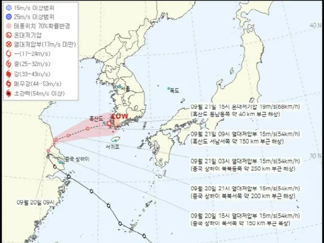
According to the Korea Meteorological Administration on the 20th, Typhoon No. 14 turned into a tropical depression in the northwest of Shanghai, China, that morning. The maximum wind speed of the center of the depression was
A tropical cyclone is a type of low pressure system weaker than a typhoon, with a wind speed of 17 meters per second or faster. Initially, Typhoon No. 14 moved inland into China, then turned eastward and entered the sea south of Jeju.
However, dry air prevented it from entering, and the forecast changed to a tropical depression weakened from Typhoon No. 14 passing between Jeju and the southern coast.
During this process, the tropical depression is expected to change into a temperate depression, compressing cold and warm air, increasing precipitation and strengthening winds.
The expected cumulative rainfall on the 20th and 21st is 30 to 100 mm in the Seoul metropolitan area (150 mm or more in southern Gyeonggi Province), and 100 to 200 mm in the Gangwon East Coast and mountain areas until the 22nd.
0mm (300mm or more in some places), Jeolla area 50-100mm (150mm or more in some places), Chungcheong area 50-100mm (150mm or more in some places)
50mm or more), Gyeongsang area 50-120mm (200mm or more on the southern coast of Gyeongsangnam), Cheju Island (excluding the northern part) 50-150mm (250mm or more in some areas).
The rain is expected to continue through the weekend of the 22nd, and the intensity of the rain is expected to be stronger than initially expected. The Japan Meteorological Agency warned that damage from strong winds is expected over the weekend, and warned that "water levels in valleys and rivers may suddenly rise.
"Therefore, please refrain from camping and take precautions against flooding in low-lying areas and isolation of underground parking lots," he said. Meanwhile, the temperature is expected to drop significantly with the heavy rains of autumn, and the high temperatures are expected to ease.
In the metropolitan area, including Seoul, morning minimum temperatures will be between 11 and 20 degrees Celsius next week, with daytime maximum temperatures between 25 and 28 degrees Celsius, which is either normal or slightly higher than average (minimum 12 to 16 degrees Celsius, maximum 23 to 26 degrees Celsius).
A Meteorological Administration official said, "Daytime temperatures across the country are expected to remain below 30 degrees next week, with the temperature difference between daytime and nighttime expected to be around 10 degrees, so typical autumn weather is expected to continue."
2024/09/20 21:27 KST
Copyrights(C) Edaily wowkorea.jp 78